QField blog

splash

QField 3.7 “Haida Gwaii”: Polishing a great experience

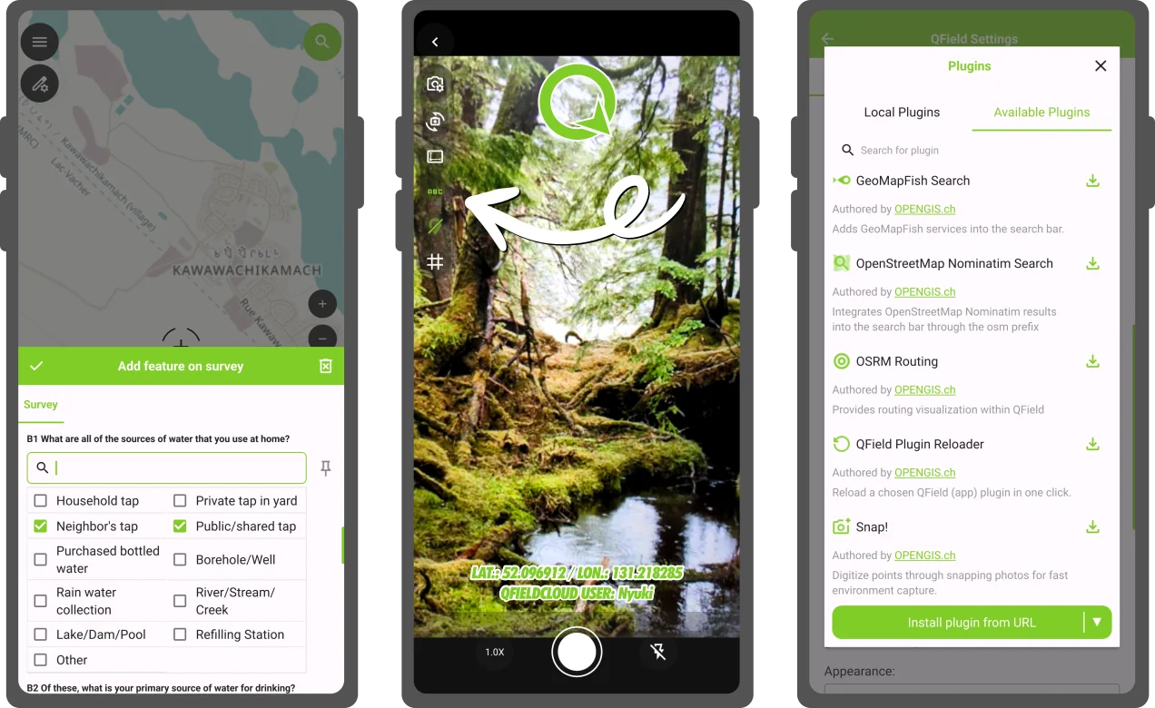
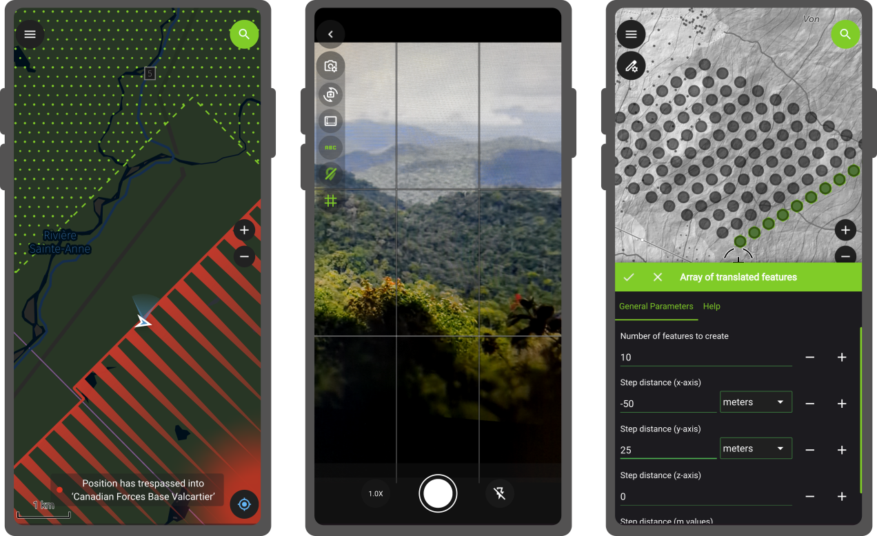
For QField 3.7, we opted for a shorter development cycle that focused on polishing preexisting functionalities from feature form editor widgets improvement through to better nearby Bluetooth device discovery. Of course, we couldn’t help ourselves and still packed in some nice functionality that we thought deserved to reach QField’s growing community as soon as possible. Main highlights One of the most interesting new functionalities from this development cycle has been the ability to stamp details on photos taken by QField’s in-app camera. A basic version of this has been supported for a while now; this new version offers flexible customisation of details stamping onto photos, including changing the font size, colour, and horizontal position, as well as providing users with the ability to completely change the details via expression-driven templates and add image overlays onto the photo. ...

August 4, 2025 · 3 min · mathieuopengisch
20250603_154007

Celebrating community, innovation, and open-source GIS in Sweden - AKA the QGIS user conference 2025

It was such a pleasure to be part of the QGIS User Conference 2025 in Norrköping! The event was extremely well organised — a big thank you to the amazing local team for pulling it all together so smoothly. Personally, it felt special to be back in Sweden, almost 20 years after my Uppsala university days. I truly enjoyed giving the opening keynote and sharing the latest from the QGIS project — and of course, showcasing all the QField greatness we’ve been working so hard on 💚 ...

June 25, 2025 · 5 min · mbernasocchi
splash

QField 3.6 “Gondwana”: Locking on greatness

Building on top of the last release which introduced background tracking, this development cycle focused on polishing functionalities and building on top of preexisting features. The variety of improvements is sure to make our diverse user base and community excited to upgrade to QField 3.6. Main highlights One of the most noticeable improvement in this version is the addition of “map preview rendering”. QField now renders partial map content immediately beyond the edge of the screen, offering a much nicer experience when panning around as well as zooming in and out. Long-time QGIS users will recognise the behaviour, and we’re delighted to bring this experience to the field ...

June 3, 2025 · 4 min · mathieuopengisch
xlsformconverter-qgis-qfield

XLSForm Converter: unlock a world of surveys with our brand new QGIS plugin

Today marks the initial release of our brand-new QGIS plugin, XLSForm Converter. As the name suggests, the plugin converts XLSForm survey files into ready-to-use QGIS projects with a preconfigured survey attribute form. Migrating to QField was never easier! Even more exciting is that the converted QGIS project includes all the necessary settings for use with QField, thanks to a nifty QFieldCloud integration. With just a single checkbox, you can upload your generated project to the cloud and begin gathering data—either as a standalone surveyor or collaboratively as part of a team. ...

June 2, 2025 · 3 min · mathieuopengisch
qf-1mio-downloads-preview

1 Million Downloads: QField's Big Milestone

🚀 QField has officially hit 1 million downloads – thanks to you! 🎉 Let’s not beat around the bush: QField has hit 1+ million downloads. What started as an ambitious open-source project has transformed into a global tool that’s changing how professionals collect spatial data in the field. This big milestone is the result of years of dedication, with over 50,000 hours invested by our team. Our GeoNinjas contributed 14% of QGIS, while also driving open-source projects like ModelBaker and SwissLocator.Thank you for making GIS nerds the unsung heroes of fieldwork everywhere. Here’s to changing the world, one field at a time! ...

May 29, 2025 · 3 min · anja
20250327_160523

FOSSGIS 2025 – What a Week!

As long time sponsors of FOSSGIS, we stepped up the game this year and became Platinum Sponsors for FOSSGIS 2025. We are proud to be part of a thriving open-source GIS community and to contribute to such a great conference. Here’s a recap of everything we were involved in: 🚀 Talks & Presentations 🌍 QField: New Strategy and Application Potential Berit and Marco presented how QField, with over 1 million downloads and 350,000 active users, is now recognized as Digital Public Good aligned with the UN Sustainable Development Goals. Marco also shared the vision and mission behind QField’s development — highlighting our commitment to empowering field teams across the globe with open, user-friendly tools for data collection. Real-world stories illustrated how QField helps bridge data gaps to support informed, sustainable decision-making. 👉 View talk ...

April 2, 2025 · 3 min · mbernasocchi

Unpacking key insights from our QField Workshop

This year, OPENGIS.ch celebrated its 10th anniversary in Bern, with an afternoon full of workshops attended by clients, long-term friends, and colleagues. Here, we will give a glimpse of QField: its vision, where it’s headed, and the exciting features future users can look forward to. QField was created on June 8th, 2011, with its first commit titled “ added first script”. Since then, it has grown into a powerful tool with a clear vision for the future: to empower people to map and understand the world, tackle daily challenges, and address global issues. Over the next ten years, QField aims to make this vision a reality for everyone, everywhere. ...

March 25, 2025 · 3 min · anja
splash

QField 3.5 “Fangorn”: Background tracking a reality!

Let’s not bury the lead here: the long-awaited capability to track position while QField is in the background or the device is locked has arrived in this brand-new version of QField. This feels like a magical moment, so we settled for a fantastical forest for our release name. Main highlights As highlighted above, QField 3.5 has unlocked background position tracking on the Android platform. This allows users to keep track of their positions even as they put QField in the background to conduct other tasks on their devices. It also means that tracking has become far more battery efficient, as users can lock/suspend their phones and tablets for long periods while QField continues to collect and track positions. On top of it all, this will work out of the book with internal GNSS as well as external high-precision GNSS devices. ...

March 4, 2025 · 3 min · mathieuopengisch
34

QField 3.4 “Ebo”: Geofencing and processing out of the box

QField 3.4 is out, and it won’t disappoint. It has tons of new features that continue to push the limits of what users can do in the field. Main highlights A new geofencing framework has landed, enabling users to configure QField behaviors in relation to geofenced areas and user positioning. Geofenced areas are defined at the project-level and shaped by polygons from a chosen vector layer. The three available geofencing behaviours in this new release are: ...

October 8, 2024 · 3 min · mathieuopengisch
qfield-rapidmapper

Rapid Mapping the Ticino Floods and Landslides with QField Rapid Mapper

QField Rapid Mapper is a project for the QField mobile app, which allows emergency responders, civil protection, military, and citizens to assess and report damages from natural catastrophes by quickly sharing geolocated images, videos and audio. QField Rapid Mapper offers real-time data collection, mapping and sharing to help enhance disaster response and coordination. QField and QFieldCloud are open-source, and OPENGIS.ch is donating the needed QFieldCloud infrastructure and expertise to help map the floods in Ticino in 2024 ...

July 7, 2024 · 3 min · mbernasocchi

QField is the leading professional fieldwork app used in enterprise settings for efficient geospatial data collection and management. As a Digital Public Good, QField not only excels in enterprise and professional applications but also contributes significantly to advancing at least six of the United Nations Sustainable Development Goals (SDGs), promoting a more sustainable and equitable future.

Stay in the loop

Subscribe to our newsletter and stay up to date on the latest and greatest!

Open-source

QField is released under the GNU Public License (GPL) Version 2 or above. Developing QField under this license means that you can inspect and modify the source code and guarantees that you will always have access to a QGIS based field data collection app that is free of cost and can be freely modified.

Privacy

View the QField Privacy Policy to learn what information is collected, used and how we protect this.

Credits

QField, QFieldCloud and QFieldSync are developped by OPENGIS.ch. OPENGIS.ch offers consulting, development, training and support for open-source software including QField, QGIS and PostGIS.