QField blog

QField 2.6 showcase

QField 2.6: perfecting high-accuracy positioning

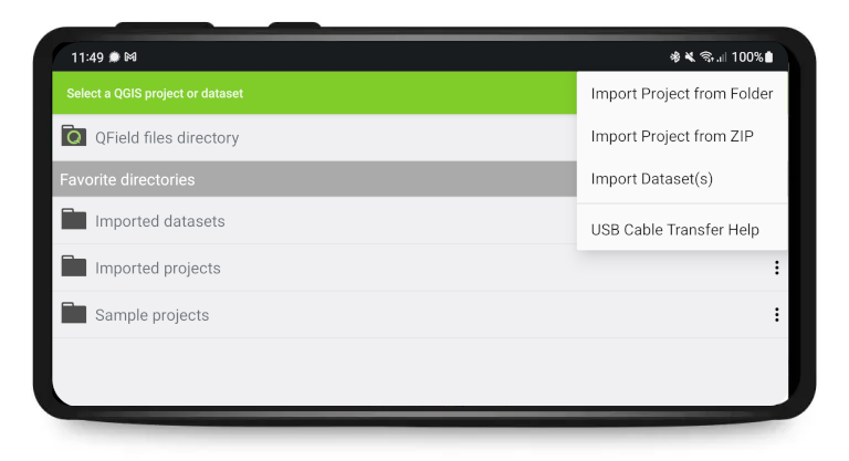
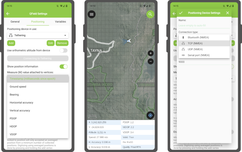
It’s only been a few weeks into the new year, but we’ve got great news for you: a brand new QField 2.6 “Geeky Gecko ?” has been released with a focus on positioning improvements, including Bluetooth support for Windows. And with that, we are delighted to remove the ‘beta’ status from QField for Windows. New positioning features Let’s open with a bang: QField 2.6 now supports NMEA streaming from external GNSS devices over TCP, UDP, and serial ports, in addition to preexisting Bluetooth connectivity. This new functionality means that QField is now compatible with a much larger range of GNSS devices out there. ...

January 26, 2023 · 2 min · mathieuopengisch
QField_AppAward_12-2022

How to contribute to QField

QField is a community-driven open-source project. It is free to share, use and modify and it will stay like that. The very essence of a community is to help and support each other. And that’s where YOU come into play. To make it work we need your support! For those who don’t know much about the concept of open source projects, a bit of background. Investing in open-source projects is a technical and ethical decision for OPENGIS.ch. Open source is a technological advantage, as we receive input from many developers worldwide who are motivated to work out the best possible software. It prevents our customers from vendor lock-in and allows complete ownership and control of the developed software. And finally, not only financially independent businesses and people should benefit from professional software but also those who might not have the financial means to pay for features, and licences. ...

December 6, 2022 · 3 min · mkuhn
25

QField 2.5 is here, reaching new heights

Our ninjas have been so busy that less than a month after we released QField 2.4, we find ourselves with so many new features we simply can’t wait any longer to present to you the latest version of QField: 2.5 “Fancy Flamingo ?”. Exciting new features QField’s main new feature of this 2.5 release cycle is its brand new elevation profiling functionality which has been added to the measuring tool. Users are now able to dynamically build and analyze elevation profiles wherever they are - in the field or on their desktop - by simply drawing paths onto their maps and projects. ...

November 14, 2022 · 2 min · mathieuopengisch
QField Werbevideo bei der Awardvergabe_c_opengis.ch

Best of Swiss Enterprise App Award for QField

What a night it was. The “Best of Swiss Apps Awards” took place in Zurich yesterday, November 2, 2022. We were also nominated with QField. And in the enterprise category, the app was so convincing, that it was awarded the highest possible price. So it brought the award “Best of Swiss Enterprise App” home to Graubünden. And as cherry on the cake: QField was also nominated as finalist in the UX/UI category! ...

November 3, 2022 · 2 min · mbernasocchi
QField 2.4 - Ecstatic Elk

QField 2.4 is here, and it is ?icious

Yes, QField for QGIS, the leading fieldwork app, was released on the iOS App Store! Get It now for Android, iOS, MacOS, Windows and Linux Good things take time (and sponsors), and we wanted our Apple users to enjoy the same solid and seamless experience as our Android users. So we took the time needed and ran beta testing of QField for multiple months. Thanks to all the community feedback and to the uncountable work hours put in by our development team, today we released QField on the iOS Appstore. ...

October 13, 2022 · 3 min · mbernasocchi
rocket

How we build QField for many platforms - A look behind the curtain

In the past year, the build system behind QField has been ported to vcpkg, a modern C++ dependency management system. It has been a great success for QField and considerably helped to streamline efforts, improve the development experience and to guarantee an outstanding stability of the application. In this blog post we will look at the history of building QGIS based applications for mobile systems and how it has become what it is today. ...

September 20, 2022 · 5 min · mkuhn
WhatsApp-Image-2022-08-22-at-13.40.29

24th Contributors QGIS Meeting in Firenze 2022

The international community of QGIS contributors got together in person from 18 to 22 August in parallel to OpenStreetMap State of The Map event and right before the FOSS4G. So there was a lot of open source geo power concentrated in the beautiful city of Florence in those days. It was my first participation and all I knew was that it’s supposed to be an unconference. This means, there is no strict schedule but space and opportunity for everyone to present their work or team up to discuss and hack on specific tasks to bring the QGIS project to the next level. ...

September 8, 2022 · 4 min · fabian
Peek-2022-07-16-12-43

A New Trick up QField’s Sleeve: Animated Maps

Starting with QField 2.2, users can fully rely on animation capabilities that have made their way into QGIS during its last development cycle. This can be a powerful mean to highlight key elements on a map that require special user attention. The example below demonstrates a scenario where animated raster markers are used to highlight active fires within the visible map extent. Notice how the subtle fire animation helps draw viewers’ eyes to those important markers. ...

August 16, 2022 · 2 min · mathieuopengisch
import

QField Users Sit Down, We Need to Talk About Storage Access on Android

TLDR: Since November 2021, Google has enforced new storage access limitations for apps published on its Play store which prohibits direct storage access on Android 11 and above forcing QField to adapt and rely on importing projects and datasets to access those. If you are a QField beta user on Android 11 and above, you might have noticed a significant change in the way the app is handling storage in the latest set of betas released in early February of 2022. This blog post will go over the changes, explain why those had to be made (looking at you, Google), how to work in this new paradigm, and showcase some new benefits from the hard work done by OPENGIS.ch’s geoninjas. ...

March 5, 2022 · 5 min · mbernasocchi
qfield-field-training

QField collected data crucial in disaster relief after Tonga’s volcanic eruption

For once, it’s not an app from the Silicon Valley, but from Laax in the Swiss Alps that made the news. By publishing QField as an open-source app, OPENGIS.ch allows companies, organisations and even countries without the necessary financial means to have the opportunity to benefit from this important data collection app. And it is being used: Over half a million downloads have already been achieved. Now, since the volcanic eruption in Tonga on 15 January 2022, the app of the small Laax-based company is playing a not-unimportant role in disaster response planning. ...

February 2, 2022 · 4 min · mbernasocchi

QField is the leading professional fieldwork app used in enterprise settings for efficient geospatial data collection and management. As a Digital Public Good, QField not only excels in enterprise and professional applications but also contributes significantly to advancing at least six of the United Nations Sustainable Development Goals (SDGs), promoting a more sustainable and equitable future.

Stay in the loop

Subscribe to our newsletter and stay up to date on the latest and greatest!

Open-source

QField is released under the GNU Public License (GPL) Version 2 or above. Developing QField under this license means that you can inspect and modify the source code and guarantees that you will always have access to a QGIS based field data collection app that is free of cost and can be freely modified.

Privacy

View the QField Privacy Policy to learn what information is collected, used and how we protect this.

Credits

QField, QFieldCloud and QFieldSync are developped by OPENGIS.ch. OPENGIS.ch offers consulting, development, training and support for open-source software including QField, QGIS and PostGIS.