QField blog

qfield-bird-plugin

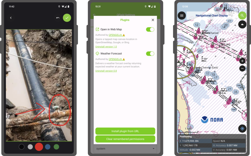
Supercharge your fieldwork with QField's project and app-wide plugins

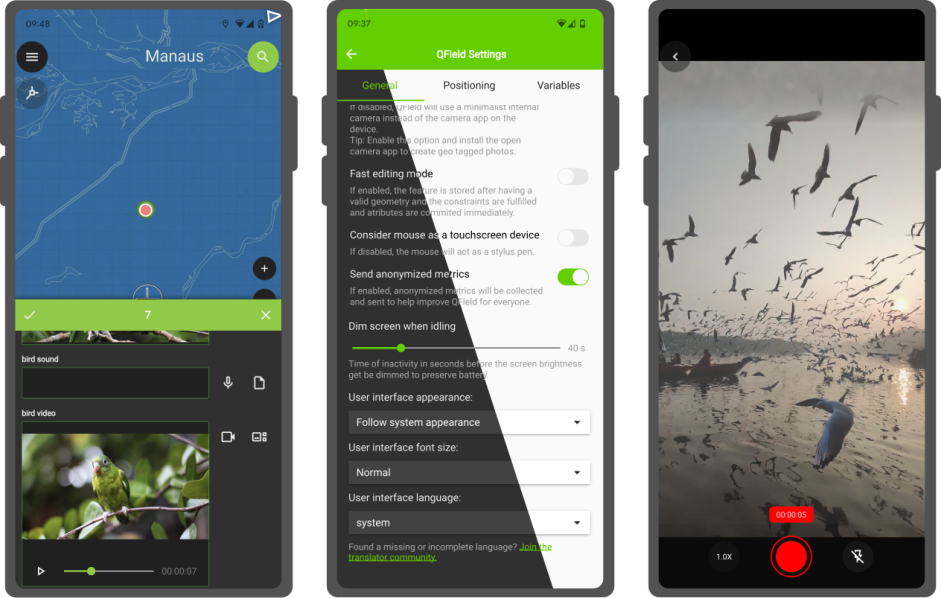
This blog post will introduce QField’s brand new plugin framework and walk through the creation of a plugin to support bird watchers in need of a quick way to digitize photos of spotted birds onto a point vector layer. A plugin framework is born! As announced recently, QField now empowers users through a brand new plugin framework allowing for simple customization on the way the application behaves or looks all the way through to creating completely new functionalities. ...

June 18, 2024 · 9 min · mathieuopengisch
33splash

QField 3.3 “Darién”: It is just the beginning

QField 3.3 has been released, and with it, we are proud to introduce a brand new plugin framework that empowers users to customize and add completely new functionalities to their favourite field application. That’s on top of a bunch of new features and improvements added during this development cycle. What preceded this moment was just the beginning! Main highlights One of the biggest feature additions of this version is a brand new drawing tool that allows users to sketch out important details over captured photos or annotate drawing templates. This was a highly requested feature, which we are delighted to bring to all supported platforms (Android, iOS, Windows, macOS, and, of course, Linux) with the financial support of the Swiss QGIS user group. ...

June 11, 2024 · 4 min · mathieuopengisch
qfield-sdg-text

QField receives prestigious recognition as a digital public good from the Digital Public Goods Alliance

We are thrilled to announce that the Best of Swiss Apps Enterprise winner 2022, QField, has been officially recognized as a Digital Public Good by the UN-endorsed Digital Public Goods Alliance . This prestigious recognition highlights QField’s significant contributions to six key Sustainable Development Goals (SDGs): SDG 6 (Clean Water and Sanitation), SDG 9 (Industry, Innovation, and Infrastructure), SDG 11 (Sustainable Cities and Communities), SDG 13 (Climate Action), SDG 15 (Life on Land), and SDG 16 (Peace, Justice, and Strong Institutions). The “Swiss Made Software” QField is the leading fieldwork application with almost 1 Million downloads worldwide. ...

June 6, 2024 · 4 min · mbernasocchi
qfield32

QField 3.2 “Congo”: Making your life easier

Focused on stability and usability improvements, most users will find something to celebrate in QField 3.2 Main highlights This new release introduces project-defined tracking sessions, which are automatically activated when the project is loaded. Defined while setting up and tweaking a project on QGIS, these sessions permit the automated tracking of device positions without taking any action in QField beyond opening the project itself. This liberates field users from remembering to launch a session on app launch and lowers the knowledge required to collect such data. For more details, please read the relevant QField documentation section. ...

April 4, 2024 · 3 min · mathieuopengisch
287987844-8d7c6540-c32c-4d62-bf6e-1636a011567f

Snappy QField 3.1 “Borneo” has arrived

The launch of QField 3.0 was a big deal, but now we’re back to focusing on smaller, more frequent updates. Don’t let the shorter change log for 3.1 trick you – there are lots of cool new features in this update! Main highlights One of the main improvements in this release is the brand-new functionality to enable snapping to common angles while digitizing. When enabled, the coordinate cursor will snap to configured angles alongside a visual guideline. This comes in handy when adding new geometries while surveying features with regular angles (e.g. buildings, parking lots, etc.). As QField gets more digitizing functionalities, we’ve taken the time to implement a nifty UI that collapses digitizing toggle buttons into a drawer, leaving extra space for the map canvas to shine through. ...

January 10, 2024 · 3 min · mathieuopengisch
Woman traveler explorer with backpack hiking to the top of the mountain. Adventure weekend.

QField background tracking

Years ago, the QField community and its users showed their love for their favourite field app by supporting a successful crowdfunding to improve camera handling. Since then, OPENGIS.ch has continued to lead the development of QField with the regular support of sponsors. We couldn’t be prouder of the progress we have made, with plenty of new features added in every major release. This includes major improvements to positioning including location tracking, integration of external GNSS receivers through not only Bluetooth but TCP/UDP and serial port connections, accuracy indicator and constraints, and most recently sensors reading to list a few. ...

June 29, 2023 · 3 min · mbernasocchi
238116107-1792bb88-9fdb-41e7-9716-7fd65f8837ce

QField 2.8: Boosting field work through external sensors

The latest version of QField is out, featuring as its main new feature sensor handling alongside the usual round of user experience and stability improvements. We simply can’t wait to see the sensor uses you will come up with! The main highlight: sensors QField 2.8 ships with out-of-the-box handling of external sensor streams over TCP, UDP, and serial port. The functionality allows for data captured through instruments – such as geiger counter, decibel sensor, CO detector, etc. - to be visualized and manipulated within QField itself. ...

May 30, 2023 · 2 min · mathieuopengisch
224213255-e51e619a-2505-49dc-a03d-088bfa2530e4

Capturing more while in the field with the new QField 2.7

A brand new version of QField has been released, packed with features that will make you fall in love with this essential open source tool all over again with a focus on capturing more while you are in the field. QField 2.7 nicknamed “Heroic Hedgehog” also includes a number of worthy fixes making it a crucial update to get. New recording capabilities The highlight of QField 2.7 is the new audio and video recording capability straight from the feature form. In addition to preexisting still photo capture, this functionality allows for video motion and audio clips to be added as attachments to feature attributes. ...

April 4, 2023 · 3 min · mathieuopengisch
QField 2.6 showcase

QField 2.6: perfecting high-accuracy positioning

It’s only been a few weeks into the new year, but we’ve got great news for you: a brand new QField 2.6 “Geeky Gecko ?” has been released with a focus on positioning improvements, including Bluetooth support for Windows. And with that, we are delighted to remove the ‘beta’ status from QField for Windows. New positioning features Let’s open with a bang: QField 2.6 now supports NMEA streaming from external GNSS devices over TCP, UDP, and serial ports, in addition to preexisting Bluetooth connectivity. This new functionality means that QField is now compatible with a much larger range of GNSS devices out there. ...

January 26, 2023 · 2 min · mathieuopengisch
QField_AppAward_12-2022

How to contribute to QField

QField is a community-driven open-source project. It is free to share, use and modify and it will stay like that. The very essence of a community is to help and support each other. And that’s where YOU come into play. To make it work we need your support! For those who don’t know much about the concept of open source projects, a bit of background. Investing in open-source projects is a technical and ethical decision for OPENGIS.ch. Open source is a technological advantage, as we receive input from many developers worldwide who are motivated to work out the best possible software. It prevents our customers from vendor lock-in and allows complete ownership and control of the developed software. And finally, not only financially independent businesses and people should benefit from professional software but also those who might not have the financial means to pay for features, and licences. ...

December 6, 2022 · 3 min · mkuhn

QField is the leading professional fieldwork app used in enterprise settings for efficient geospatial data collection and management. As a Digital Public Good, QField not only excels in enterprise and professional applications but also contributes significantly to advancing at least six of the United Nations Sustainable Development Goals (SDGs), promoting a more sustainable and equitable future.

Stay in the loop

Subscribe to our newsletter and stay up to date on the latest and greatest!

Open-source

QField is released under the GNU Public License (GPL) Version 2 or above. Developing QField under this license means that you can inspect and modify the source code and guarantees that you will always have access to a QGIS based field data collection app that is free of cost and can be freely modified.

Privacy

View the QField Privacy Policy to learn what information is collected, used and how we protect this.

Credits

QField, QFieldCloud and QFieldSync are developped by OPENGIS.ch. OPENGIS.ch offers consulting, development, training and support for open-source software including QField, QGIS and PostGIS.